Powerlines, pylons and pipes

Gordon Walker – Visiting Professor of Geography

As we have travelled through the fantastic and diverse landscapes of Iceland, infrastructural networks have been continually present. They have enabled and supported our visit in many different ways. The transport infrastructure of roads, petrol stations, signs, cattle grids, bridges and other connected technologies have enabled our movement and our rapid transition from one landscape experience and evaluation to another. The electricity network of powerlines, pylons and substations has powered the places we have stayed in, the shops and restaurants we have consumed in, the cameras and phones we have charged overnight. The extraordinary geothermal heat networks that supply heat and hot water to over 90% of Icelandic homes, have warmed us and provided sulphurous showering experiences.  The mobile communication network has kept us in touch with international events – many we would maybe rather not really know about – and enabled the ongoing blogging and tweeting that this writing is part of.  Without infrastructure, our research visit would not be, could not be, what it has been.

Pylons in the lupins - Southern Iceland, G. Walker, 2016

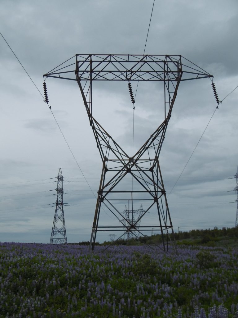
Pylons in the lupins – Southern Iceland, G. Walker, 2016

Some of this infrastructure, and its working, is invisible – pipes and cables hidden underground, text messages flying through the air – but much is in the landscape and part of it.  Pylons and powerlines accompanied our traversing of the open, flat sandar of the southern coast and traced their way up into remote valleys and open countryside to connect even the most isolated homes to the electricity grid.  Communication masts, we noted several times, were now the dominant features of settlements when viewed from a distance, usurping the traditional vertical supremacy of church steeples.  The pipelines of geothermal systems formed striking linear and zig-zagging shapes across open hillsides that otherwise took more natural, vegetated or rugged forms.

Normally hidden underground pipes in Reykjavík, G. Walker

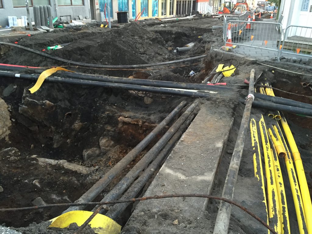
Normally hidden underground pipes in Reykjavík, G. Walker,2016

How we evaluate the status of such infrastructure within landscapes is clearly a matter of judgement and far from straightforward. Whether it jars, confronts us as out of place, detracts from the ‘natural’ and the ‘wild’, or the ‘traditional’ and the ‘vernacular’, and, crucially, whether its purpose and value justifies its presence, are all wrapped in what we see (and don’t see) and what we tolerate or object to.  In particular experience shows that the patterns of opposition to new infrastructure can often centre on the how its value is distributed across society – how widely and collectively its benefits and positive outcomes are felt and realised.

Geothermal system pipelines, Iceland, F. Tweed, 2015

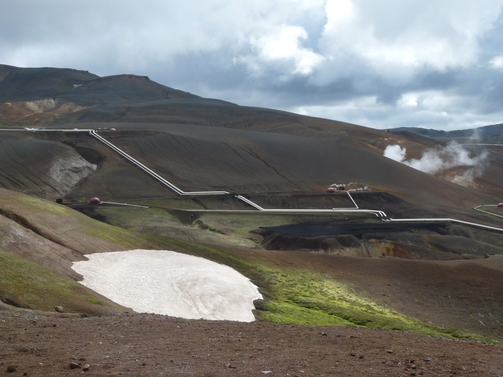
Geothermal system pipelines, Iceland, F. Tweed, 2015.

In Iceland this has been a crucial part of controversy about new hydroelectric dams in the highlands, and related electricity distribution network upgrading.  In a country where electricity is already low carbon and cheap, and where heat supply is almost entirely geothermal, why should new energy infrastructure, particularly in areas of high landscape value be needed?  The answer is not for the collective everyday needs of ordinary Icelanders, but for attracting further investment into the big conglomerate-owned aluminium industry, which already consumes nearly 80% of all electricity in Iceland; as well as for flowing energy into the grand dreams of international interconnectors that would enable Iceland to become a low carbon energy source for Europe.  Compare the widely dispersed collective benefits of communication masts or geothermal heating, with the particular national and international interests behind these big energy infrastructure investments and something at least of the complexity of making sense of existing and new infrastructures within Icelandic landscapes becomes apparent.

Going, going… not quite gone?

Fi washing up 1989

Washing up in a stream at Sólheimajökull whilst doing PhD fieldwork in 1989 (image: Fiona Tweed)

I first came to Iceland in 1989 as a PhD student on a tight fieldwork budget doing very specific physical geography fieldwork at Sólheimajökull, an outlet glacier of the Mýrdalsjökull ice cap in the south of the island. I still remember the thrill of getting close to the ice for the first time, walking on it and camping by it for weeks on end to undertake my field research. Since 1989, I have returned to Iceland over 25 times as part of a number of different research projects, field trips and excursions, each visit welding me even more closely to somewhere I regard as a second home. Over the course of the last 27 years (over half my lifespan!), Iceland has changed radically. During the last decade in particular, I’ve noticed the expansion of coach tours, adventure holidays, new infrastructure and the dramatic increase in the numbers of people visiting this windswept geological showcase in the mid-Atlantic. Returning to my PhD field site as part of this landscape research, we can view it as a microcosm of change.

The two-lane tarmacked road to Sólheimajökull, which I first drove up last year, is a stark reminder of how much has changed. There are two car parks, a café constructed from shipping containers, several picnic tables and a way-marked trail to the ice front. I cast back to arriving here in the late 1980s and early 1990s, walking up a gravel track and camping behind a moraine. There was no visible infrastructure and no defined route to the ice. Few people visited, even though the glacier front or ‘snout’ was so clearly visible from the main road. However, the greatest transformations for me as a glacial geomorphologist are recorded by the physical landscape; the ice retreat here is phenomenal and has been documented by many – including  James Balog in his film Chasing Ice and as part of the Extreme Ice Survey project: http://extremeicesurvey.org/

Staffs students on ice 2003

Staffordshire University Geography students working on the ice, 2003 (image: Fiona Tweed)

In trying to explain this to my companions, the magnitude of the changes becomes even more apparent, along with the implications for the landscape research in which we are engaged. The ice has been retreating since the late 1990s; any frequent visitor would notice that the walk to the glacier snout has become longer each year. I estimate that the frontal position is now at least 1.5km away from where it was in the late 1990s. But it is the thinning of the ice which appears most profound to me, with bare rock slopes on the valley walls marking where the glacier once sat. The glacier snout is being effectively drowned by the meltwater that it produces; a lake has been forming for the past few years and now separates the ice from the outwash plain in front of it. All of this means that the landscape view has changed – and this is happening at other locations across Iceland.

Ice margin in 2004

Sólheimajökull ice margin, 2004 (image: Fiona Tweed)

Ice margin and lake in 2014

Sólheimajökull ice margin and proglacial lake, 2014 (image: Fiona Tweed

How do I feel about the changes? Saddened by the pace of ice retreat and resigned to the inevitable encroachment that tourism brings. But I’ve been privileged to work at this glacier over many years and my intimate relationship with Iceland germinated here; coming back is like visiting an old friend.

2016

Sólheimajökull, June 2016, holding an image from 2007 for comparison (image: Fiona Tweed)

Black Ice = Dirty Ice?

Getting up close and personal with a glacier for the first time is an unforgettable experience. I first studied glacial geomorphology over 25 years ago and the strange vocabulary of the science still trips off the tongue: roches moutonnées, drumlins, ablation, calving, moraines. I have stood in the great glaciated landscapes of North Wales and Scotland and showed students the terrain carved by past glaciers – “U-shaped valleys anyone?” These all record the passage of glaciers long since gone – melted away as the British climate warmed. The landscapes that remain record the rock-grinding power of frozen water moving inexorably downhill.

Sólheimajökull glacier, Southern Iceland, June 2016. Photo F. Tweed.

Sólheimajökull glacier, Southern Iceland, June 2016. Photo F. Tweed.

But seeing an active glacier up close for the first time is astonishing. It’s all about scale, you need to stand well back to appreciate the enormity of an Icelandic glacier. From a distance, the edges are black, jumbled, craggy, only rising to a glacial whiteness higher up, away from the snout and the valley edges. Here the whiteness sometimes makes the edges hard to discern, they disappear on cloudier days high into the sky. There is no getting away from it – these things are vast.

Getting close in however, something changes in your appreciation of the aesthetics of the glacier. In my first attempt to capture the important landscape components of Iceland I had written “black, dirty ice”, a negative thing. What we want is unsullied, non-retreating (!) white ice. Black ice would work to depress the landscape quality rating, whereas white ice would raise it.

Sólheimajökull glacier, Southern Iceland, June 2016. Photo F. Tweed.

Sólheimajökull glacier, Southern Iceland, June 2016. Photo F. Tweed.

How wrong can you be? How deceptive a photograph is sometimes.

Standing with my palm on the rising front of Sólheimajökull glacier,  I was completely knocked out by the beauty of the black; in the matt ash cones, the stripes of glacial blue, black and grey. It is the black which defines the craggy beauty of the crevasses, the blocks, the lines. It makes the glacial blue stripes emerging from the centre of the ice seem even more blue. The black shows clearly the business of the glacier as it gathers material and grinds it down.

Black ice = dirty ice? Well maybe from a distance, but black ice is beautiful.

R. Swetnam in front of Sólheimajökull glacier, Southern Iceland, June 2016. Photo D. Chambers.